Fires Rage in Georgia
NASA...

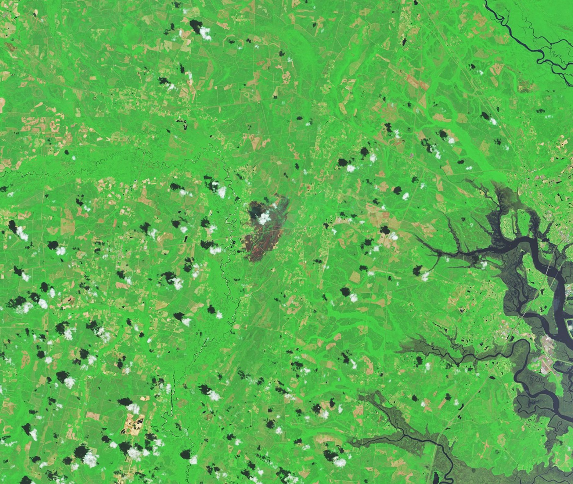
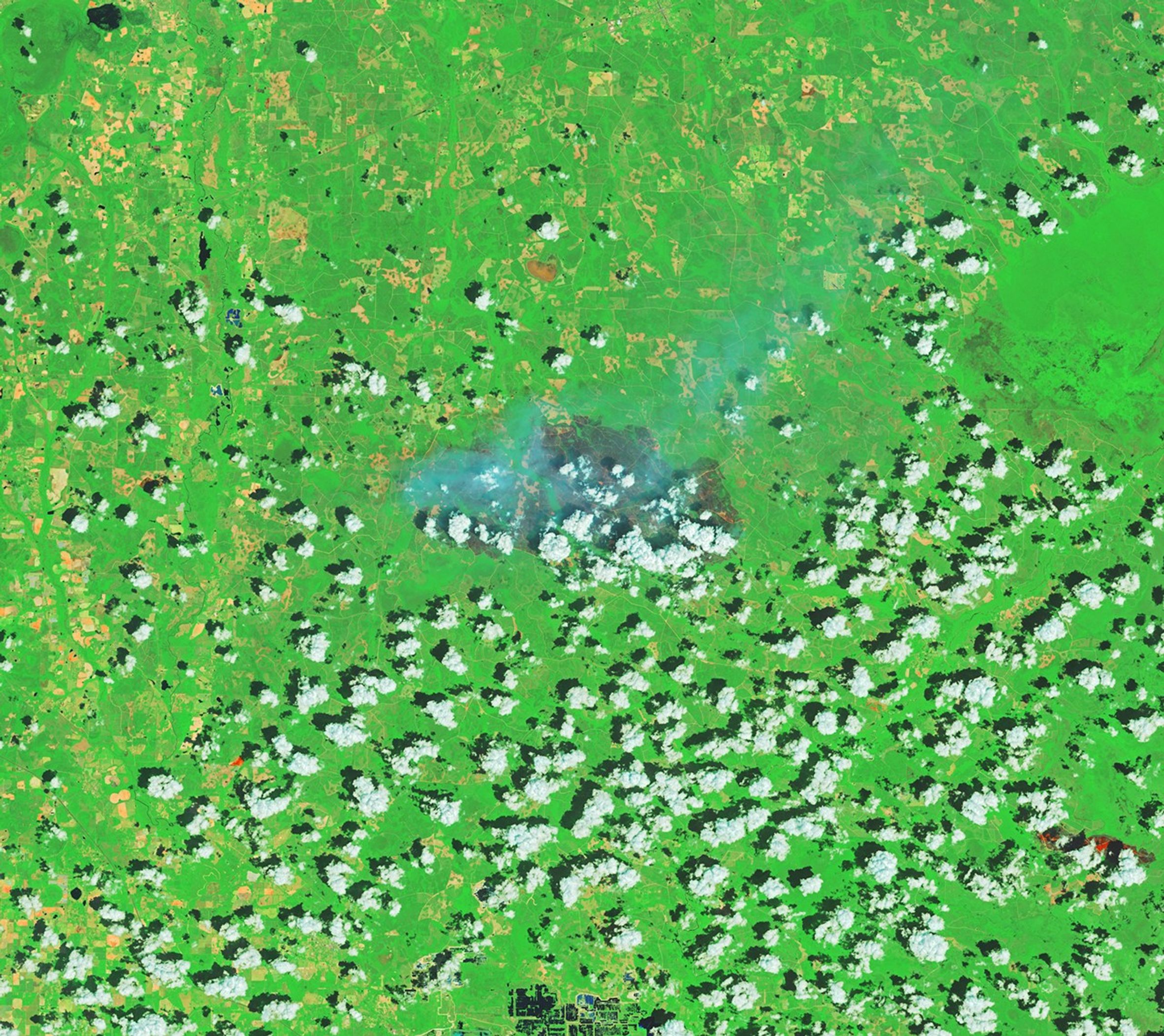
An extreme drought that has gripped the Southeast for months helped fuel two large, destructive, human-caused wildland fires in southern Georgia in April 2026. The Pineland Road and Highway 82 fires together burned more than 50,000 acres (20,000 hectares) as of April 28, according to the Georgia Forestry Commission.
Satellite images of the fires captured by Landsat 8 show charred forests and residential areas in and around Atkinson (above) and Fruitland (below). The images are false color (bands 7-5-4), in which burned areas appear gray and vegetated areas green. The infrared signatures of actively burning fire fronts are orange. By April 25, the fires had destroyed more than 120 homes—the most lost to wildfire in the state’s history, according to news reports.

The Highway 82 blaze started on April 18 with a spark from a welding operation, and the Pineland Road fire ignited three days later after a mylar balloon collided with power lines. Both blazes spread rapidly amid blustery winds in areas that were parched by months of limited rainfall. Fallen trees and limbs left by Hurricane Helene in September 2024 also helped fuel the fires, according to forestry officials.
Heavy rains helped firefighters battle the blazes in recent days, but the Pineland Road fire remained 23 percent contained and the Highway 82 fire 32 percent contained on April 28, the forestry commission reported. Hundreds of firefighting personnel are confronting the fires with equipment in the air and on the ground.
NASA’s satellite and aircraft data are part of a global system of observations used to track fire behavior, analyze emerging trends, and develop technology that operational agencies can use to manage wildfires across the United States. Among the real-time wildfire monitoring tools that NASA makes available are FIRMS (Fire Information for Resource Management System), the Worldview browser, and the Fire Event Explorer.
NASA Earth Observatory images by Michala Garrison, using Landsat data from the U.S. Geological Survey. Story by Adam Voiland.
References & Resources
- AP, via U.S. News & World Report (2026, April 23) Debris From Hurricane Helene Is Helping Fuel Georgia’s Wildfires. Accessed April 28, 2026.
- CBS 47 & Fox 30, via Yahoo! News (2026, April 25) Georgia loses most homes in state’s history to wildfires in Brantley, Clinch counties. Accessed April 28, 2026.
- Georgia Forestry Commission (2026, April 28) Current Wildfire Information. Accessed April 28, 2026.
- Highway 82 Fire Information, via Facebook (2026) Posts. Accessed April 28, 2026.
- NASA Earthdata (2026) Wildfires. Accessed April 28, 2026.
- NASA Earth Observatory (2026, April 7) Drought Parches Florida. Accessed April 28, 2026.
- NASA Intro to FireSense. Accessed April 28, 2026.
- Savannah Morning News (2025, April 27) Update on wildfires in Georgia today. Here is the latest in GA. Accessed April 28, 2026.
- U.S. Drought Monitor Current Map. Accessed April 28, 2026.
- Wildfire Explorer (2026, April 28) Wildfire Explorer. Accessed April 28, 2026.
You may also be interested in:
Stay up-to-date with the latest content from NASA as we explore the universe and discover more about our home planet.

Dry, warm, and windy conditions across the U.S. Great Plains led to extreme fire activity in March 2026.

Satellite-based maps show northern wildland fires becoming more frequent and widespread as temperatures rise and lightning reaches higher latitudes.

Tens of thousands of people fled to safety as blazes spread throughout the country’s Biobío and Ñuble regions.