Belts of Green in the Washington Suburbs

NASA...
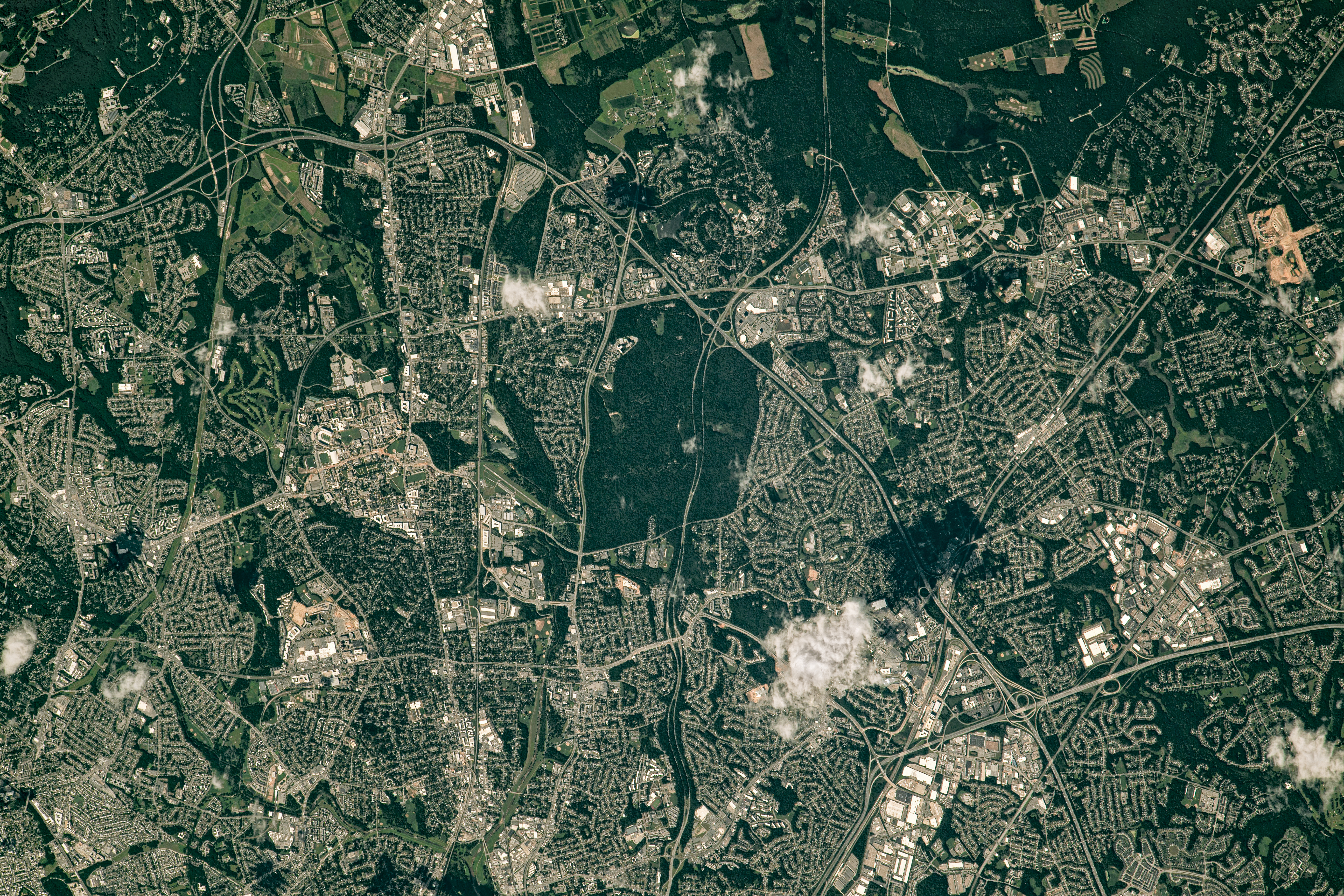
Beyond the border of Washington, D.C., numerous suburbs spread across Virginia and Maryland. Many are accessible from the Capital Beltway (I-495), the highway that encircles Washington. An astronaut on the International Space Station captured this photo of the beltway’s northeast side where it passes through the historic city of Greenbelt, Maryland.
The photo was taken on July 30, 2023, a time of year when the region’s vegetation is lush and green. One of the more prominent green spaces in this image is Greenbelt Park. The park’s nearly 5 square kilometers (2 square miles) contain forested hiking trails, several picnic areas, and a campground. The land was once intended as a future extension of the city of Greenbelt, but it was acquired by the National Park Service in 1950.
Just north of the park, Greenbelt’s historic district is laid out in a crescent shape. The district is one of three planned communities that arose in the 1930s as part of the New Deal program, intended to provide work for the unemployed and to create affordable cooperative housing with accessible green space. Homes connect to walking paths, which in turn connect to one of the country’s oldest planned shopping centers.
A collection of buildings east of the beltway is NASA’s Goddard Space Flight Center, established in Greenbelt on May 1, 1959, as NASA’s first spaceflight complex. Several patches of forested land separate some of the buildings. The large green spaces north of Goddard are a mix of forested land and agricultural fields in the town of Beltsville, which include University of Maryland and USDA agricultural research sites. The main campus of the University of Maryland is visible just west of Greenbelt in College Park.
Other nearby tree-lined areas are visible as well. For instance, Hyattsville, just south of College Park, has been recognized as a “tree city” for more than three decades. In addition, trees line a large segment of the Baltimore-Washington Parkway (MD-295), which runs north-south between Baltimore and Washington and bisects Greenbelt Park.
Astronaut photograph ISS069-E-39302 was acquired on July 30, 2023, with a Nikon D5 digital camera using a focal length of 1150 millimeters. It was provided by the ISS Crew Earth Observations Facility and the Earth Science and Remote Sensing Unit at NASA Johnson Space Center. The image was taken by a member of the Expedition 69 crew. The image has been cropped and enhanced to improve contrast, and lens artifacts have been removed. The International Space Station Program supports the laboratory as part of the ISS National Lab to help astronauts take pictures of Earth that will be of the greatest value to scientists and the public, and to make those images freely available on the Internet. Additional images taken by astronauts and cosmonauts can be viewed at the NASA/JSC Gateway to Astronaut Photography of Earth. Story by Kathryn Hansen.

References & Resources
- Greenbelt Museum, Greenbelt History. Accessed April 20, 2026.
- National Park Service, Foundation Document Overview. Accessed April 20, 2026.
- National Park Service (2026) Greenbelt Park, Maryland. Accessed April 20, 2026.
- National Park Service (2018, July 2) Greenbelt Historic District. Accessed April 20, 2026.
- The Washington Post (2025, December 10) In Greenbelt, Md., New Deal history meets co-op spirit. Accessed April 20, 2026.
You may also be interested in:
Stay up-to-date with the latest content from NASA as we explore the universe and discover more about our home planet.

The Large Magellanic Cloud—one of our closest neighboring galaxies—is a hotbed of star formation that is visible to both astronauts…

A dusting of white highlighted the Colorado Plateau around the deep gorge, while shadows created a visual illusion.

Satellites are helping land managers track ecological shifts as reserves reconnect and landscapes return to a more natural state.