World Cup Fever in Guadalajara
NASA...

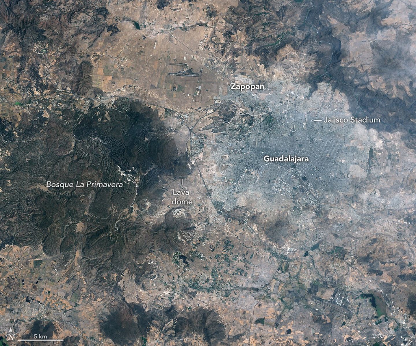
April 13, 1986
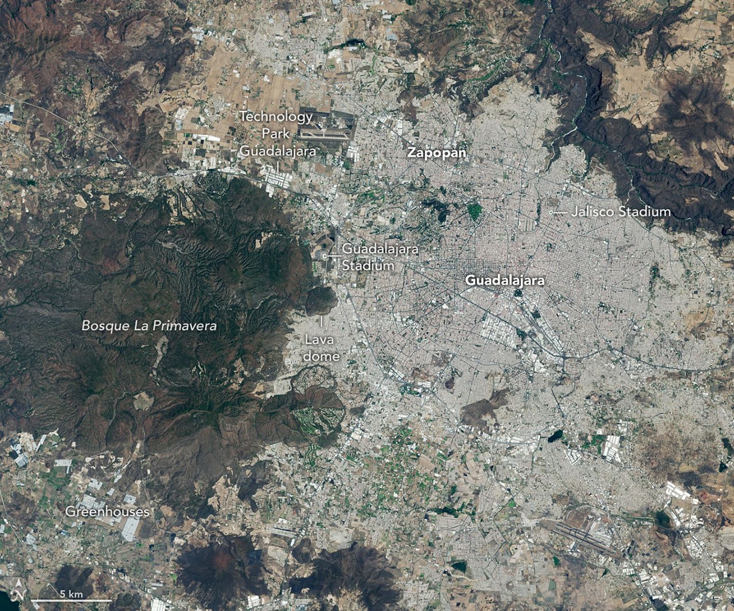
April 27, 2026
April 13, 1986 – April 27, 2026
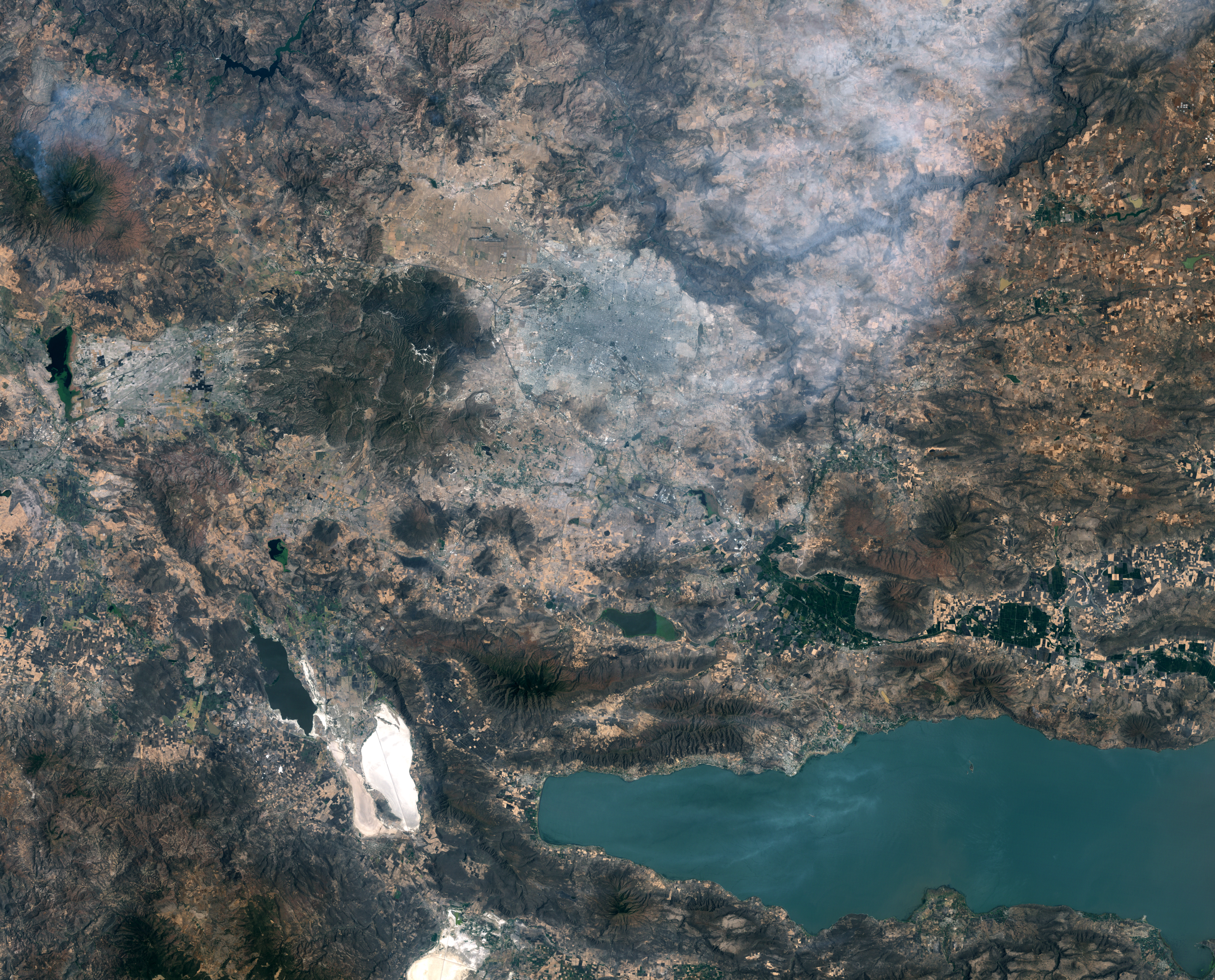
Guadalajara, Mexico, was quite a different place when it last hosted World Cup games 40 years ago. The city welcomed matches in June 1986 and did so again in 2026, when South Korea faced Czechia at Guadalajara Stadium in the opening round of the 2026 FIFA World Cup.
In 1986, Guadalajara Stadium had not yet been built in Zapopan, the fast-growing municipality just northwest of Guadalajara. Many of that year’s World Cup matches were held instead at Jalisco Stadium in northeastern Guadalajara. It was in that stadium that France defeated Brazil in a penalty shootout in the 1986 quarterfinals, in what is widely regarded as one of the most memorable World Cup games of all time.
As seen in the Landsat images above, the land where Guadalajara Stadium (also called Estadio Akron) now sits was farmland in 1986. The new stadium, built in 2010 to host Mexico’s Club Deportivo Guadalajara, or Chivas, lies near the Sierra la Primavera volcanic complex, a rugged landscape full of lava flows, volcanic domes, steam vents, and hot springs. The architects who designed the stadium took inspiration from the nearby volcanic terrain, creating a structure that rises from a grassy earthen berm meant to resemble the flanks of a volcano, topped with a white roof reminiscent of a volcanic cloud.
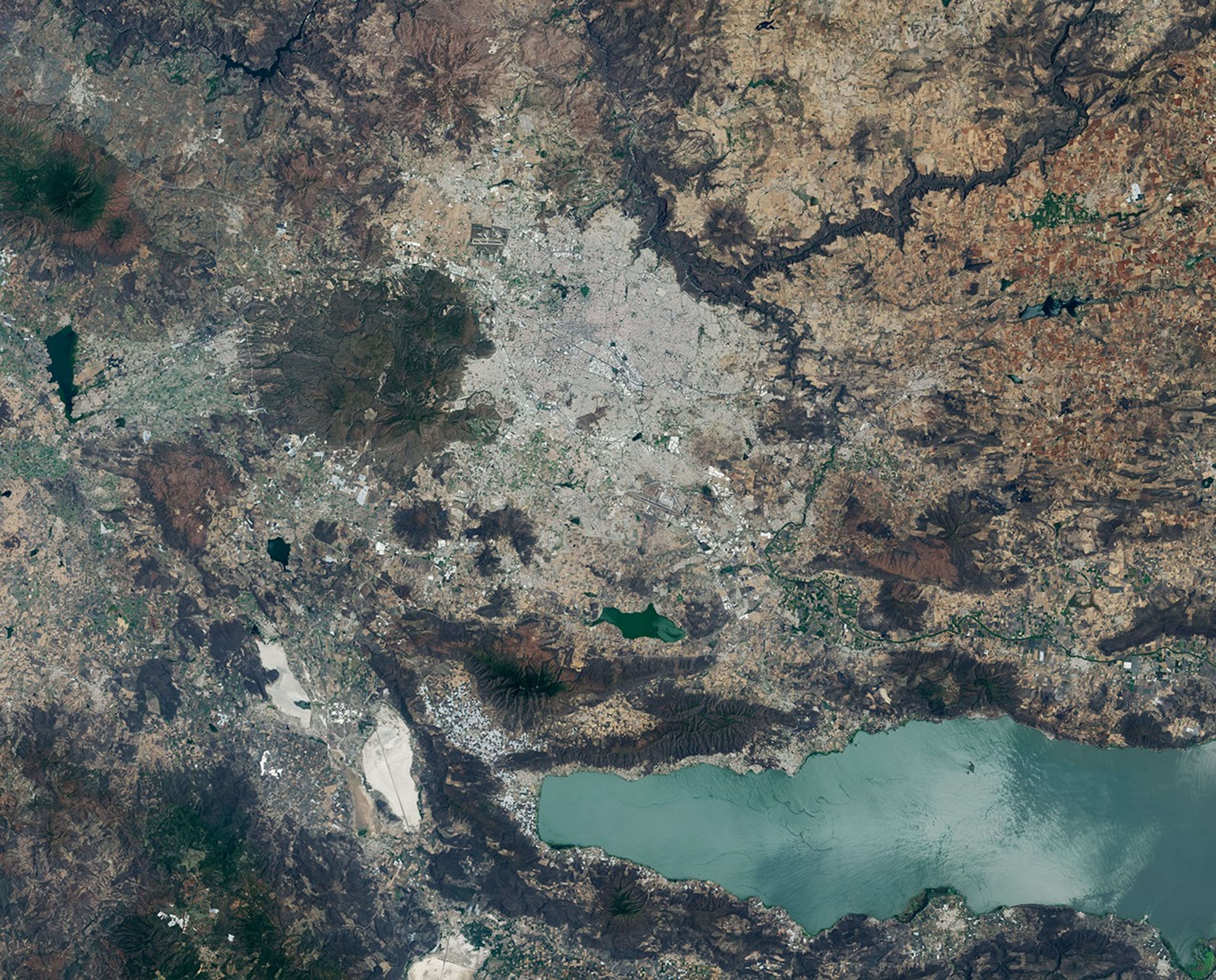
About 95,000 years ago, the volcanic system underneath Sierra la Primavera produced a massive eruption that caused a caldera 11 kilometers (7 miles) in diameter to slump downward. Water filled the depression for tens of thousands of years, but tectonic uplift and the accumulation of sediment eventually led to the demise of the lake. Erosion wore away the softer surrounding rock over time, leaving harder, erosion-resistant volcanic rocks within the circular feature that now stand high above the surrounding terrain.
Starting about 60,000 years ago, several lava domes erupted along the southern edge of the caldera. The youngest of them, Cerro del Colli, formed about 30,000 years ago, leaving the dome-shaped feature just south of the stadium and contributing to a broader landscape dotted with other volcanic domes and cinder cones.
Today, much of the original caldera has been preserved as a forested area known as La Primavera Biosphere Reserve, even as development has partially encircled it during the past 40 years. The population of the Guadalajara metro area has grown from about 2.7 million in 1986 to more than 5.5 million now, with particularly rapid growth in Zapopan, a burgeoning tech hub sometimes billed as “Mexico’s Silicon Valley.” A prominent development visible in Landsat images is Guadalajara Technology Park, one of several new industrial parks in Zapopan. New greenhouses have also come to the area en masse, including south of the reserve, where they are mostly used to grow fruits and vegetables.
World Cup fever runs particularly high in Guadalajara, which is hosting World Cup matches for the third time. During Brazil’s legendary title run in 1970, when Pelé led the team, Jalisco Stadium was the venue for Brazil’s first-round, quarterfinal, and semifinal matches. To commemorate him, the city in May 2026 erected a 9.5-meter (31-foot) bronze statue of the iconic football (soccer) player.
Even the animals at Guadalajara Zoo are taking part in the festivities, with elephants, gorillas, giraffes, capybaras, pumas, and macaws “predicting” match winners by choosing between food, shirts, boxes, soccer balls, and other items. A puma named Muluk predicted South Korea would beat Czechia by sniffing and moving a ball, one newspaper reported.
Guadalajara will host four first-round matches: South Korea vs. Czechia on June 12, Mexico vs. South Korea on June 18, Colombia vs. Democratic Republic of the Congo on June 23, and Uruguay vs. Spain on June 26.
NASA Earth Observatory images by Lauren Dauphin, using Landsat data from the U.S. Geological Survey. Story by Adam Voiland.

References & Resources
- Chivas (2020, July 30) The birth of a dream: Akron Stadium. Accessed June 11, 2026.
- designboom (2010, August 9) new estadio chivas by jean-marie massaud + daniel pouzet. Accessed June 11, 2026.
- Earth Matters (2018, June 14) World Cup 2018: A Satellite, Soccer Balls, and Spectacular Space Images. Accessed June 11, 2026.
- ESPN (2026, May 21) Towering Pelé statue unveiled in Guadalajara before World Cup. Accessed June 11, 2026.
- FIFA (2022, August 24) The thriller that marked the end of an era for Brazil. Accessed June 11, 2026.
- FIFA (2021, June 2) Guadalajara. Accessed June 11, 2026.
- Football 2026 (2026, May 31) The Legend of Estadio Jalisco: Guadalajara’s Iconic Stadium and Its World Cup Legacy. Accessed June 11, 2026.
- Mexico News Daily (2026, June 8) Wild picks: Elephants, pumas and gorillas make World Cup predictions at Guadalajara Zoo. Accessed June 11, 2026.
- NASA (2026, June 8) How NASA Science and Artemis Are Shaping the 2026 FIFA World Cup. Accessed June 11, 2026.
- NASA Earth Observatory (2022, November 19) Stadium City Qatar. Accessed June 11, 2026.
- NASA Earth Observatory (2014, June 16) National Stadium of Brasília. Accessed June 11, 2026.
- Sourisseau, D., et al. (2026) Stratigraphy and dynamics of the 6.4 ka explosive rhyolitic eruption at Colli dome, La Primavera caldera, Mexico. Bulletin of Volcanology, 88(6).
- Stadium Journey (2006, April 8) Ancient Inspirations to FIFA World Cup 2026: The Story of Estadio Akron, the Newest Ancient Stadium in the World. Accessed June 11, 2026.
You may also be interested in:
Stay up-to-date with the latest content from NASA as we explore the universe and discover more about our home planet.

A massive, old caldera and more recently formed craters shape the landscape in the eastern Sierra Nevada.

The hill-shaped features are a sign of explosive volcanic activity—a rarity on the Red Planet.

Episode 43 of the Hawaiian volcano’s current eruption was marked by high lava fountains and widespread ash dispersal.
